Services

- Our Solutions
We Offer a Range of Services to Meet Your Needs
With a focus on innovation, quality, and efficiency, PEINSO is dedicated to providing comprehensive offshore and onshore survey services that meet the evolving needs of our clients.
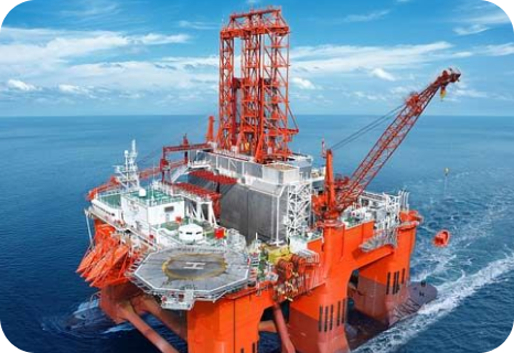
At PEINSO, we provide high-precision positioning services to support offshore and onshore oil & gas operations, ensuring accuracy, efficiency, and safety in critical marine activities. Our expertise in offshore positioning services enables seamless project execution across various applications.
Our Key Positioning Solutions:
✅ Anchor Handling – Precision anchor handling operations to ensure stable and secure offshore installations.
✅ Rig Move – Safe and efficient rig positioning and relocation, minimizing downtime and maximizing operational productivity.
✅ Pipeline & Cable Lay Support Survey – Advanced pipeline and cable lay support surveys, providing real-time positioning data for seamless underwater installations.
✅ Well-head Positioning – Accurate well-head positioning to enhance drilling efficiency and ensure structural integrity.
Our positioning services integrate the latest geophysical survey techniques and offshore data processing to deliver real-time monitoring, enhanced navigation, and operational accuracy for oil & gas projects.
At PEINSO, we provide high-precision ROV Inspection Services to support offshore oil and gas operations, ensuring maximum efficiency and safety in complex underwater environments.
Our Services Include:
✅ ROV Rig Approach Survey – Accurate assessment of offshore rig locations before installation to ensure optimal alignment and risk mitigation.
✅ Platform Inspection – High-resolution imaging and structural assessment of offshore platforms to detect damage and corrosion.
✅ Pipeline Inspection – Detailed analysis of subsea pipelines to identify leaks or damages that may impact operational performance.
✅ Seabed Survey – Comprehensive seabed mapping using advanced geophysical data to support offshore construction and planning.
Using geophysical survey technologies and state-of-the-art ROV systems, we provide detailed data that enhance maintenance efficiency, minimize operational risks, and optimize performance in offshore environments.
At PEINSO, we provide comprehensive geotechnical services designed to support offshore and onshore projects with precise data and expert analysis. Our services ensure the stability, safety, and efficiency of infrastructure development in the oil & gas, marine, and construction industries.
Our Key Geotechnical Services:
✅ Borehole Survey – Conducting advanced subsurface investigations to determine soil and rock properties, ensuring accurate foundation design and stability assessments.
✅ Soil Investigation – Delivering in-depth soil testing and analysis to assess bearing capacity, composition, and geotechnical characteristics for optimal project execution.
✅ Drop Core & Grab Sampling – Collecting high-quality seabed and soil samples to evaluate environmental conditions, sediment composition, and material suitability for offshore and onshore developments.
With cutting-edge technology and a team of seasoned geotechnical experts, PEINSO delivers accurate, data-driven insights to mitigate risks and optimize project performance.
At PEINSO, we specialize in Geophysical Analogue & Digital Survey services, utilizing cutting-edge technologies to deliver precise and reliable subsurface mapping solutions. Our services support various offshore and onshore operations, ensuring accurate data acquisition for informed decision-making.
Our key offerings include:
✅ Bathymetric Survey – Providing high-resolution seafloor mapping to support offshore construction, dredging, and resource exploration.
✅ Site Survey – Conducting detailed site investigations to assess seabed conditions, detect hazards, and ensure project feasibility.
With our advanced geophysical survey systems, high-precision data processing, and expert team, we deliver industry-leading geophysical services that meet international standards for safety and efficiency.
Our ROV & Intervention Services are designed to provide precise subsea inspection and intervention solutions, ensuring efficient and safe offshore operations. With advanced remotely operated vehicle (ROV) technology, we offer a range of specialized services, including:
✅ ROV CP Survey – Conducting Cathodic Protection (CP) surveys to assess corrosion levels on subsea structures.
✅ ROV UT Survey – Utilizing Ultrasonic Thickness (UT) testing for precise measurement of subsea asset integrity.
✅ ROV FMD Survey – Performing Flooded Member Detection (FMD) surveys to identify water ingress in structural components.
✅ Drilling Support – Assisting in offshore drilling operations with real-time monitoring and intervention capabilities.
✅ Pipeline Repair Intervention – Delivering ROV-assisted pipeline repair and maintenance solutions to ensure operational continuity.
Our team employs cutting-edge ROV technology and real-time data acquisition systems to enhance decision-making, reduce risks, and maximize operational efficiency in offshore oil and gas environments.
At PEINSO, we have established one of the largest Data Processing Centers in both the Egyptian and global offshore oil & gas market. Our center operates with two key principles in mind:
✅ Highly Skilled Experts – Our team consists of seasoned professionals with over 20 years of experience in data gathering and processing, ensuring accuracy and efficiency.
✅ Advanced Software Capabilities – We utilize a comprehensive suite of industry-leading software, including EIVA (offline & online), CODA (offline & online), BeamWorx, SonarWiz, HiPAC, and more, to deliver precise and reliable data solutions.
Our expertise enables us to process complex geophysical, hydrographic, and environmental data efficiently, supporting offshore and subsea operations with cutting-edge technology and deep industry knowledge.
We provide specialized training programs designed to enhance technical expertise in offshore and onshore operations. Our courses combine comprehensive theoretical materials with hands-on practical training, ensuring industry professionals gain the necessary skills to excel in oil & gas services.
Our training covers:
✅ ROV Operations & Maintenance – Hands-on experience with ROV systems for inspection and intervention.
✅ Geophysical & Geotechnical Survey Training – In-depth knowledge of survey methodologies and data interpretation.
✅ Offshore Positioning & Navigation – Expertise in positioning services for marine operations.
✅ Health, Safety & Environmental (HSE) Training – Ensuring compliance with industry safety standards.
Our courses are designed for engineers, technicians, and professionals looking to advance their expertise in the oil & gas sector
At PEINSO, we provide comprehensive onshore services, specializing in GIS & mapping solutions tailored for the oil and gas industry. Our team consists of highly skilled professionals with extensive expertise in various fields, ensuring accurate data collection, mapping, and geospatial analysis to support industry operations.
Our onshore services include:
✅ Photogrammetry Mapping – High-precision aerial and satellite mapping for detailed terrain analysis.
✅ Geodetic Engineering – Advanced geodetic surveying techniques ensuring accurate positioning.
✅ Surveying (Marine and Land) – Specialized marine and land surveying to optimize project execution.
✅ GIS/GPS Services – Cutting-edge GIS & GPS solutions for spatial data management and navigation.
✅ Civil Engineering – Expertise in infrastructure planning and development.
✅ Reliable Management & Accountability – Ensuring operational efficiency and compliance.
✅ Geotechnical Expertise – Providing soil investigation and borehole surveys for construction and resource extraction.
✅ Business Management & Marketing – Strategic planning to enhance project success and industry positioning.
Our onshore solutions empower businesses with precise geospatial data, enabling efficient decision-making and optimized project execution across various sectors.
We utilize cutting-edge technology in marine services and GIS to ensure precise and efficient data collection. Our capabilities include:
✅ 360 Radar Cameras – Providing high-resolution imaging for enhanced situational awareness.
✅ OGLS – Advanced geospatial laser scanning for accurate mapping.
✅ Multi-Beam Echo Sounders – Delivering detailed underwater topography.
✅ Radio Detection (RD) – Identifying subsurface utilities with precision.
✅ Subsea Scanners – Capturing high-quality underwater imagery.
✅ Arc GIS – Powerful spatial analysis and mapping tools.
✅ Single Beam Echo Sounders – Reliable depth measurement solutions.
✅ HydroPro – Specialized hydrographic data processing system.
✅ Ground Penetrating Radar (GPR) – Detecting underground structures with accuracy.
Our expertise ensures reliable, high-quality data collection for marine, land, and geospatial applications, supporting industries in infrastructure, environmental studies, and resource management.
We provide comprehensive Geographic Information System (GIS) services, enabling our clients to analyze and manage spatial data efficiently. Using the latest mapping technologies and spatial analysis tools, we offer a wide range of solutions, including:
✅ Contour Mapping for infrastructure projects and planning.
✅ Thematic Mapping to analyze various environments and natural resources.
✅ Cadastral Mapping to support urban planning and land management.
✅ Environmental Mapping for studying environmental impacts and land use analysis.
✅ Zonal Mapping to assist in regional planning and urban expansion.
Our GIS solutions help businesses effectively manage geospatial data, leading to more accurate decision-making and enhanced project planning
At PEINSO, our GLS Mapping Services provide cutting-edge GIS mapping solutions that enable users to visualize, analyze, and manage spatial data with precision. By leveraging advanced technology and industry expertise, we offer a range of specialized mapping services, including:
✅ Spatial Maps – Comprehensive representation of geographic data for analysis and planning.
✅ Atlas Maps – Professionally designed maps for reference and navigation.
✅ Contour Maps – Detailed elevation maps to support topographical analysis.
✅ Thematic Maps – Customized maps highlighting specific themes or data patterns.
✅ Cadastral Maps – Accurate property boundary mapping for land management.
✅ Landscape Maps – Visualizing terrain features for environmental and urban planning.
✅ Zonal Maps – Defining specific geographic zones for resource allocation and development.
✅ Environmental Maps – Supporting sustainability and ecological studies.
Our GLS Mapping Services empower industries such as oil & gas, infrastructure, urban planning, and environmental management with actionable insights, enhancing decision-making, optimizing operations, and ensuring accuracy in spatial data analysis.
